There is a road through the Elah Valley that the Philistines used and that the tribes of Israel watched. It runs between the coastal plain and the Judaean highlands, through the vale where tradition places the duel of David and Goliath. Anyone who controlled the ridge above it controlled the approach to the hill country. Someone understood that very clearly around 1000 BCE. They built a town on the highest point - a town so heavily fortified, so precisely planned, that it stands today as the best-preserved early Israelite city wall in existence. Its modern name is Khirbet Qeiyafa. Its ancient name may have been Sha'arayim - the city of two gates.
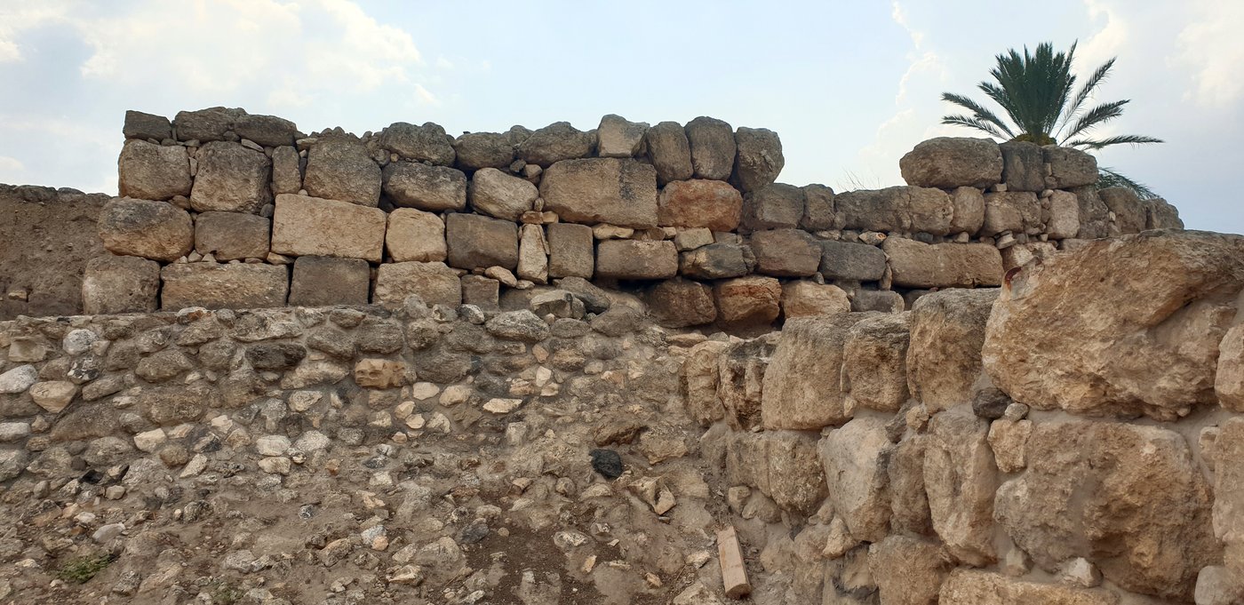
What makes Khirbet Qeiyafa extraordinary is not only its walls, though those are remarkable enough. It is the combination of ambition, precision and brevity. The town was built in a single phase, occupied for perhaps forty to fifty years, and then vacated in an orderly way - no destruction layer, no ash, no enemy celebration. The inhabitants left, taking their valuables with them. The stones stayed. They are still there, still casemate walls in the Iron Age IIA style: two parallel walls tied together with cross-walls, the spaces between them used as rooms or storage. The whole perimeter runs nearly seven hundred metres. That is not a watchtower. That is a statement.
The record
Systematic excavations at Khirbet Qeiyafa were directed by Yosef Garfinkel (Hebrew University of Jerusalem) and Saar Ganor (Israel Antiquities Authority) beginning in 2007. Radiocarbon dating of olive pits and other organic material from the site produced dates in the range of 1050-915 BCE, with the most concentrated results centring on the late 11th to early 10th century BCE - placing the occupation firmly in the Iron Age IIA and within the historical horizon associated with the United Monarchy. Finds are held at the Israel Antiquities Authority and described in Garfinkel and Ganor, Khirbet Qeiyafa Vol. 1: Excavation Report 2007-2008 (Hebrew University / Israel Exploration Society, 2009).
The two gates are the architectural feature that most fires the imagination. Almost no other Iron Age I or IIA site in the region has two city gates. Sha'arayim is mentioned three times in the Hebrew Bible - once in the account of the aftermath of the Goliath duel, which the text places in this very valley. Garfinkel and Ganor argue that the double-gate plan matches the biblical name and that Khirbet Qeiyafa is the most plausible candidate for that site. The argument is contested - it always is at this level of the early Iron Age - but the matching of a two-gate layout to a name that means literally "two gates" in Hebrew is the kind of convergence that makes even sceptics pause. Inside the walls, the excavators found what appears to be a planned street grid, storerooms lining the inner face of the casemate wall, and a possible public building - the bones of organised civic life, not a seasonal camp. The site produces animal bones from which pig is almost entirely absent, a dietary pattern consistent with the Israelite cultural horizon as known from other sites of the same period.
The record
The casemate wall at Khirbet Qeiyafa is estimated to have required some 200,000 tonnes of stone and a labour force on a scale that implies central coordination, not village effort. The wall itself is between 2.5 and 4 metres wide, with an outer wall, an inner wall, and cross-walls creating the characteristic Iron Age casemate rooms. Two gates have been excavated on the site perimeter - one facing south-west toward the Elah Valley, one facing north - which is architecturally unusual for sites of this period and scale. The near-absence of pig bones in the faunal assemblage is consistent with a population observing Israelite dietary practice; by contrast, contemporary Philistine sites in the same region show pig consumption at significant levels. This evidence is published in Garfinkel, Ganor and Hasel, Khirbet Qeiyafa Vol. 3: The 2009-2013 Excavation Seasons (Hebrew University / Israel Exploration Society, 2018).
The short life of the fortress is one of the most thought-provoking aspects of the site. No enemy burned it. The finds show a town that was planned, built, inhabited, and then deliberately left. The most widely accepted explanation is political: with the consolidation of the Judaean hill-country polity under a stronger central authority - a king who could project power without a chain of border forts - the strategic logic of an exposed frontier garrison faded. The people withdrew. Their walls did not. For three thousand years, Khirbet Qeiyafa sat on its ridge in the state its last occupants left it, until twenty-first-century excavators came and found a city gate still at coursing height. That is a kind of permanence nobody planned for. The tribe built to hold a road for a generation, and held the road in stone forever.
The record
The biblical text of 1 Samuel 17:52 names Sha'arayim in connection with the Elah Valley battle account. The place-name Sha'arayim (שַׁעֲרַיִם) means "two gates" in Hebrew. Garfinkel and Ganor proposed Khirbet Qeiyafa as its identification partly on the basis of the double-gate plan, the Elah Valley location, and the 10th-century BCE date; the proposal is supported by scholars including Michael Hasel (Southern Adventist University) and critiqued by others who favour different identifications or who date the site differently. The name Sha'arayim also appears in Joshua 15:36 and 1 Chronicles 4:31 as a Judaean town, supporting a Judaean rather than Philistine or Canaanite attribution for the site. The double-gate plan and its significance are discussed in Garfinkel, Ganor and Hasel, Khirbet Qeiyafa and the Biblical Tradition, Journal of Hebrew Scriptures 12 (2012).
Khirbet Qeiyafa does not resolve every argument about Israelite statehood or the nature of the United Monarchy. It was not meant to. It is one fortress, one generation, one ridge. But it is an extraordinary witness to the ambition and capacity of the Judaean highland polity at precisely the moment when the tradition says a kingdom was forming. Someone, in the years around 1000 BCE, looked out across the Elah Valley and decided this ridge needed walls. They built them well. Three millennia later, those walls are still the best evidence we have that the tribe was not merely surviving in its hills but actively shaping the geography of power around them.