Beneath the modern Jewish Quarter of Jerusalem's Old City, a set of massive vaulted substructures still runs underground, built to carry a building so large that the ground itself had to be levelled and reinforced before it could stand. Nothing above ground survives to prove what once sat on top of them. What survives is the platform, and a Greek inscription cut into the plaster of one of its chambers, and the outline of a colonnaded street that once ran past its front door. Together they let archaeologists put a name to the vaults: the Nea Ekklesia, the New Church of the Mother of God, built by the emperor Justinian I and dedicated in 543 CE - one of the largest church buildings ever raised in the ancient world, on Jerusalem's southern ridge, in a Christian empire that had by then held the city for two centuries.
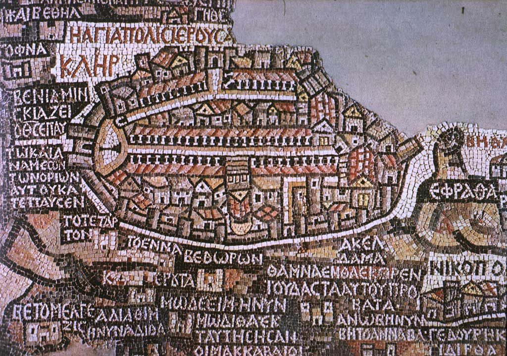
The church itself is gone. What makes it usable evidence is that it did not have to be reconstructed from guesswork alone. A sixth-century writer in Justinian's own service, Procopius, described the building's construction in detail in his work on the emperor's buildings - the scale of the site, the difficulty of the terrain, the columns brought from elsewhere in the empire to complete it. A near-contemporary mosaic map, discovered laid into the floor of a church in Madaba, in modern Jordan, shows Byzantine Jerusalem from above and includes what is generally read as the Nea's distinctive silhouette at the southern end of the city's main colonnaded street. And beneath the Jewish Quarter, excavation found the vaults themselves, at the scale the ancient description implied, at the location the mosaic map implied. Three independent sources - a textual account, a pictorial map, and a hole in the ground - describe the same building. That convergence is the whole case.

The Nea Ekklesia
A vast basilica dedicated to the Mother of God, commissioned by Justinian I and dedicated in 543 CE on Jerusalem's southern ridge. Ancient description places it among the largest churches built anywhere in the empire; to raise it on sloping, uneven ground, its builders first constructed an enormous platform of vaulted chambers, several of which survive intact beneath the modern Jewish Quarter. A large Greek dedicatory inscription, naming Justinian and referring to the building's completion, was found cut into the plaster of one of these vaults.
In situ, Jewish Quarter, JerusalemA street drawn on a floor
The second piece of the evidence is not underground but overhead, in a building hundreds of kilometres away. In the late nineteenth century, workmen in the town of Madaba uncovered the floor of a Byzantine-era church covered in a mosaic map of the biblical world, its centrepiece an oval-shaped bird's-eye view of Jerusalem, rendered in astonishing architectural detail for a floor decoration: gates, walls, towers, and running straight through the middle of the walled city, a broad colonnaded street flanked by shaded porticoes on both sides. That street is the Cardo Maximus, the north-south spine of the Byzantine city, and at its southern end the map shows a large building with a gabled roof that most readers take to be the Nea.
A map made for a church floor is not a surveyor's plan, and it was never meant to be checked against a trowel six centuries later. That it can be checked at all is what makes it more than devotional art. When archaeologists traced the line of Jerusalem's Byzantine Cardo through the Jewish Quarter, they found a colonnaded street of roughly the width and orientation the mosaic implies, running on the axis the mosaic implies, terminating close to where the mosaic's large gabled building sits. A picture drawn from memory and piety by an artisan who had probably visited the city turned out to be geographically usable.
The Byzantine Cardo
A colonnaded street running north-south through Jerusalem's Old City, extended and monumentalised under Justinian to connect the city centre to the newly built Nea Church. A stretch of the street, with its paving, column bases and flanking shops, was excavated in the Jewish Quarter and has been partly reconstructed and left open to view along its original line. Its position and proportions correspond closely to the street shown running through walled Jerusalem on the Madaba mosaic map.
In situ, Jewish Quarter, JerusalemWhy it matters as evidence
None of this material was produced with an eye to proving anything about Jewish history directly - the Nea was a Christian imperial monument, built to celebrate Byzantine Jerusalem's role as a pilgrimage capital, and it stands in a period when Jewish residence in the city itself was heavily restricted under Byzantine rule. Its evidentiary value lies elsewhere: it fixes, with unusual precision, what Byzantine Jerusalem actually looked like on the ground during the centuries between the city's paganisation under Rome and its conquest by Islamic armies in the seventh century - the built environment that Jewish communities living nearby, and Jewish memory of the city across the diaspora, had to reckon with as the real, physical Jerusalem of their own lifetimes.
That is the quiet use of a site like this. It anchors an entire span of the city's history to a set of coordinates that can be walked, measured and photographed, rather than left to depend on any single written source. A church described by an imperial biographer, painted on a mosaic floor two hundred kilometres away, and rediscovered under a modern housing estate all describe the same stones. When independent records converge that tightly on one patch of ground, the ground itself becomes hard to argue with.
Further reading